Today was the “big day” of the trip at least from my perspective, as it had been a dream of mine to visit – Angkor Wat. Unfortunately, Tachy had to stay behind as the many steep and uneven steps the day before at Pre Rup had affected her and she felt (in retrospect, very wisely) to give her leg a bit of a rest.
The group set off, as usual at 7 AM to beat the crowds and heat, again very wisely. Angkor Wat together with Angkor Thom are the central groups of structures in the vast Angkor complex (which at it’s peak had a population of about 1 million) and was the mausoleum of the Khmer King Suryavarman II in the early 12th century in Yaśodharapura (present-day Angkor), which was the capital of the Khmer Empire. Note – I define certain terms that may be new to some readers at the bottom of this posting.
For those who have been here, it is a sight you will never forget and I’m sure you will remember all the details. However, for those that have not, let me put it all into perspective. Here I use information from the guide and from other literary and web sources.
First it seems prudent to discuss – Cambodia, Kampuchea, (French Indochina) and Khmer. Cambodia is the current name of the country, but used to be called, and still sometimes is referred to as Kampuchea (Khmer empire). When the French ruled the area, now Cambodia, Viet Nām, Laos etc the area was known as Indochina. The majority of Cambodians are ethnic Khmer as it has been for centuries. The language spoken in Cambodia is Khmer which is written in a very similar script to Sanskrit. At some other point I’ll discuss the script, and linguistics, probably as a post unto itself. Suffice it to say that it has tones, 23 vowels, and about 10 more consonants, as well as a special Syllabic structure with “o” and “e” vowels .
The Khmer Empire (known as Kampuchea, “Srok Khmer” to Khmer people) was a Hindu-Buddhist empire that ruled over most of what we know as Southeast Asia (parts of modern-day Laos, Thailand, and southern Vietnam). Its greatest legacy is Angkor, which was the capital city during the empire’s zenith. Recent satellite imaging has revealed Angkor to be the largest pre-industrial urban center in the world.
King Jayavarman II — the founder of Angkor – who ruled 790-850 (the latter date may be earlier) was probably a prince from Java who gained power conquering a series of competing kings, and in 790 became king of a kingdom called “Kambuja” by the Khmer. He was the one who founded the Angkor period in Cambodian history, beginning with a grandiose consecration ritual that he conducted in 802 on the sacred Mount Mahendraparvata, now known as Phnom Kulen, to celebrate the independence of Kambuja from Javanese dominion. At that ceremony Prince Jayavarman II was proclaimed as universal monarch or God King.
Angkor as Khmer Capital, grew in power over the next rulers. He was succeeded by his son Jayavarman III supposedly in 850 and died in 877 and was succeeded by Indravarman I (reigned 877 – 889) who managed to expand the kingdom I without wars.
Indravarman I was followed by his son Yasovarman I (reigned 889 – 915), who established a new capital, Yasodharapura – the first city of Angkor. The city’s central temple was built on Phnom Bakheng, a hill which rises around 60 meters above the plain on which Angkor sits. Under Yasovarman I the East Baray was also created, a massive water reservoir of 7.5 by 1.8 km. At the beginning of the 10th century the kingdom split. Jayavarman IV established a new capital at Koh Ker, some 100 km northeast of Angkor. Rajendravarman II (reigned 944 – 968) returned to rule in Yasodharapura (Angkor). The son of Rajendravarman II, Jayavarman V, reigned from 968 to 1001 with new temples constructed, the most important of which is Banteay Srei. There were a succession of rulers, but the Golden age can be considered during the period of Suryavarman II (reigned 1113–1150) the builder of his own mausoleum which took 37 years – Angkor Wat, dedicated to God Vishnu.
The next important king was Jayavarman VII (reigned 1181–1219), generally considered as Cambodian’s Greatest King. The Cham (who ruled southern Viet Nām) had conquered Angkor in a naval battle at Tonlé Sap lake in 1177, however, Jayavarman VII gathered an army and regained the capital. He continued the war for another 22 years, until the Khmer defeated the Champa in 1203 and conquered large parts of its territory. Jayavarman VII was the last of the great kings of Angkor establishing the new capital, now called Angkor Thom (literally: “Great City”). In the centre, he constructed Bayon, as the state temple with towers bearing faces of the boddhisattva Avalokiteshvara, each several metres high, carved out of stone. Further important temples built under Jayavarman VII were Ta Prohm, Banteay Kdei, and Neak Pean, as well as the reservoir of Srah Srang (all of these form part of the Angkor Complex, and other than seeing the reservoir, we did not visit the others).
After the death of Jayavarman VII, his son Indravarman II (reigned 1219–1243) ascended the throne.
He was succeeded by Jayavarman VIII (reigned 1243–1295) a devotee of the Hindu deity Shiva, under whose rule he was threatened by the Mongols under Kublai Khan’s and over the next years the Thai revolted and the empire went into decline, with the capital bring moved to modern day Phnom Penh, leaving a small group at Angkor. There is evidence for a further period of use of Angkor. Under the rule of king Barom Reachea I (reigned 1566–1576), who temporarily succeeded in driving back the Thai, the royal court was briefly returned to Angkor.
Now we have a bit of an idea about the Khmer Empire, and some of it’s key rulers, it’s time to discuss a bit further the key temples and locations we visited in the Angkor Complex which for ease of remembering, I’ll discus in the order we visited:-
A. TA PROHM
Ta Prohm, originally called Rajavihara (“monastery of the king”), (“ancestor Brahma”), was built about 1 Km East of Angkor Thom, in the Bayon style by King Jayavarman VII as a Mahayana Buddhist monastery and university in the late 12th and early 13th centuries . The stela commemorating the foundation gives a date of 1186 AD / CE. It was constructed in honor of his family with the main image, representing Prajnaparamita, the personification of wisdom, (modeled on the king’s mother). The northern and southern satellite temples in the third enclosure were dedicated to the king’s guru and his elder brother respectively. The main image of which represented the Bodhisattva of compassion Lokesvara and was modelled on the king’s father.
The temple’s stele records that the site was home to more than 12,500 people (including 18 high priests and 615 dancers), with an additional 800,000 – 1,000,000 individuals in the surrounding villages working to provide services and supplies. The temple continued as late as the rule of Srindravarman at the end of the 15th century.
Like most Khmer temples, Ta Prohm is oriented to the east. The outer wall of 1,000 by 650 metres encloses an area of 650,000 square metres that at one time would have been the site of a substantial town in the 13th century. The faces on the towers look similar to those found at the Bayon were added to the gopuras. The trees over time have grown around the structures and the archaeologists decided to leave them for fear of the collapse and to preserve it in its natural state. This has made it a stunning backdrop for films like “Raiders of The Lost Ark” that used it for location shooting.
B. PRE RUP
Pre Rup was built as the state temple of Khmer king Rajendravarman and dedicated in 961 or early 962. It is a temple mountain of combined brick, laterite and sandstone construction.
The temple’s name means “turn the body”. This reflects the common belief among Cambodians that funerals were conducted at the temple, with the ashes of the body being ritually rotated in different directions as the service progressed.
It’s located just south of the eastern reservoir, (or Royal Swimming Pool as our guide indicated that is good for laps of you are really fit – 700 meters long by 300 meters wide or 2,300 X 1,000 feet)! Pre Rup is aligned on a north-south axis. The construction is of laterite (stone) and brick giving it a pleasing reddish tone that is heightened by early morning and late afternoon sunlight, which is when we were there. We climbed to the top for great views and the sunset was looking spectacular, however about 10 minutes before it crossed the horizon, it dipped behind a cloud. Thus we all descended while it was still light.
It has a square lay-out and two perimeter walls. The outer enclosure is a platform bounded by a laterite wall, 117 meters N-S by 127 meters E-W. The four external gopuras are cross-shaped, having a central brick section (consisting of three rooms flanked by two independent passageways) and a sandstone vestibule on both sides. To either side inside the eastern gate is a group of three towers aligned north to south and a series of long distinct galleries running along each side, a distinctive feature of 10th century Angkor architecture.
The final squared pyramid, measuring 50 meters at its base, rises in three steep tiers a dozen metres in height to a 35 m square platform at the summit which is where we stood to see the sunset. The lowest tier is symmetrically surrounded by 12 small shrines. At the top, five towers are arranged in a quincunx, one at each corner of the square and one in the center. Deities carved as bas-reliefs stand guard at either side of the central tower’s eastern door; its other doors are false doors. The southwest tower once contained a statue of Lakshmi, the northwest tower a statue of Uma, the southeast tower a statue of Vishnu and the northeast tower a statue of Shiva. The last one has an inscription on doorjambs that dates from Jayavarman VI.
Pre Rup was dedicated to the Hindu god Shiva, and it is probably located on a former shivaite ashram, built by Yasovarman I.
C. ANGKOR WAT
Angkor Wat was first a Hindu, later a Buddhist, temple complex built by the Khmer King Suryavarman II (ruled 1113 – c. 1150) in the early 12th century as his state temple and eventual mausoleum. Breaking from the Shaiva tradition of previous kings, Angkor Wat was instead dedicated to Vishnu.
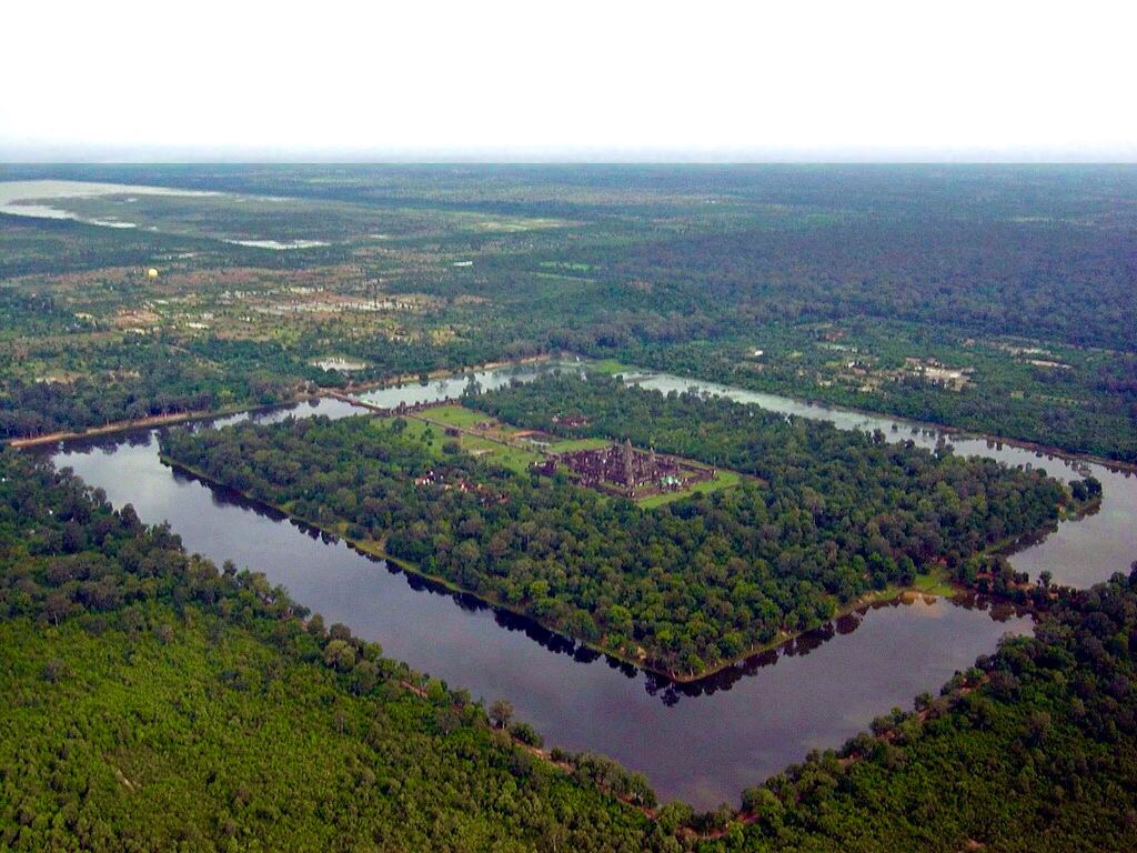
Angkor Wat combines two basic plans of Khmer temple architecture: the temple-mountain and the later galleried temple, based on early Dravidian architecture, with key features such as the Jagati. It is designed to represent Mount Meru, home of the devas in Hindu mythology: within a moat and an outer wall 3.6 kilometres (2.2 mi) long are three rectangular galleries, each raised above the next. At the centre of the temple stands a quincunx of towers. Unlike most Angkorian temples, Angkor Wat is oriented to the west, which according to our guide was because of he setting sun.
The modern name, Angkor Wat, means “Temple City” or “City of Temples” in Khmer; Angkor, meaning “city” or “capital city”, is a vernacular form of the word nokor, which comes from the Sanskrit word nagara. Wat is the Khmer word for “temple grounds” (Sanskrit – “enclosure”).
The outer wall, 1,024 by 802 meters and 4.5 m high, is surrounded by a 30 m apron of open ground and a moat 190 m wide. There are gopuras at each of the cardinal points; the western is by far the largest and has three ruined towers. Under the southern tower is a statue of Vishnu. Galleries run between the towers and as far as two further entrances on either side of the gopura often referred to as “elephant gates”, as they are large enough for those animals to fit through. There were elephants available for tourists to hire and ride in through the impressive carved gates, but we walked!
The outer wall encloses a space of 820,000 square metres (203 acres), which besides the temple proper was originally occupied by the city and, to the north of the temple, the royal palace.
The temple stands on a terrace raised higher than the city. It is made of three rectangular galleries rising to a central tower, each level higher than the last. The outer gallery measures 187 by 215 m, with pavilions rather than towers at the corners. The gallery is open to the outside of the temple, with columned half-galleries extending and buttressing the structure. The second-level enclosure is 100 by 115 m, and may originally have been flooded to represent the ocean around Mount Meru. The tower above the central shrine rises 43 m to a height of 65 m above the ground. Integrated with the architecture of the building, and one of the causes for its fame is Angkor Wat’s extensive decoration, which predominantly takes the form of bas-relief friezes.
The Angkor Wat Temple consumed about 6 million to 10 million blocks of sandstone with an average weight of 1.5 tons each. In fact, the entire city of Angkor used up far greater amounts of stone than all the Egyptian pyramids combined, and occupied an area significantly greater than modern-day Paris. The sandstone had to be transported from Mount Kulen, a quarry approximately 25 miles (40 km) to the northeast.
According to our guide it took 350,000 workers, 34,000 elephants and 20,000 boats to construct the structures.
D. TONLÉ SAP LAKE
This river / lake at our visit, was brown, muddy unappealing and 1 1/2 meters (5 feet) deep. Boats were getting stuck and single file was the order of the day. During the rainy season the area under water swells to make it the biggest freshwater lake in South East Asia. A few details:-
It is unusual for two reasons: its flow changes direction twice a year, and the portion that forms the lake expands and shrinks dramatically with the seasons. From November to May, Cambodia’s dry season, the Tonlé sap, as most rivers, drains into the Mekong River at Phnom Penh then past the Mekong Delta in Viet Nām and into the South China Sea. (indeed Phnom Penh, was built at the convergence of the Tonlé sap River and the Mekong River). The Tonlé sap has an area of 2,700 square kilometres (1,000 sq mi).
However, when the year’s heavy rains begin in June, the Tonlé sap backs up (reversing the river flow) to form an enormous lake area of approximately 16,000 square kilometres (6,200 sq mi), with a depth of nine to fifteen meters.
This expansion floods the nearby fields and forests, providing a great breeding ground for fish. Indeed fishing during this time is actually illegal, so as to prevent disruption of mating and next season’s fishing which is the lifeblood of the food in the region.
The Tonlé sap is also unusual for its biannual flow reversal. The river reaches maximum flow in August and September, when the Mekong River swells massively as it collects melted water from the Himalayas as well as heavy monsoon rains in its upstream drainage basin which spans five countries. Coverging with the Tonlé sap in the Cambodian capital, the volume surge reverses much of the flow back up into the Tonlé sap floodplain.
At the start of the dry season, the Mekong River water levels drop, returning the Tonlé sap River flow to its usual seaward direction, exposing the muddy lake plain.
Catching fish is simple, but the aftermath takes much more time and effort. Because the drop in the water level, the Tonlé sap naturally carries away thousands of fish. The fishermen simply place cone-shaped nets into the water from their floating houses and then lift the net as soon as seconds later trapping two or three tons of fish each time and more than ten thousand tons of fish can be caught in under a week. One by one, fishermen, mostly women, cut off the fish heads then bring the fish back to the river to be cleaned and to remove the fat. Salting the fish for preservation is the final step in this process, but the fish will continue to macerate for several months in order to transform into a paste called prahok, a nourishing condiment that complements almost any dish.
The interesting thing from our standpoint was seeing all the floating fishermen’s houses. Mostly Vietnamese, their houses are simple and anchored with bamboo poles to the river bed. Painted blue, between 500 and 1,000 houseboats form a village that, as we saw contained floating gardens, schools, churches, basketball court, even pigs in a pen. We saw children swimming in the water, one woman washing her hair and life progressed with all residing on their respective boats. Very colorful as the pictures show.
E. ANGKOR THOM / BAYON / ELEPHANT TERRACE
Angkor Thom, was established in the late twelfth century by King Jayavarman VII. It covers an area of 9 km², within which are located several monuments from earlier eras as well as those established by Jayavarman and his successors. At the centre of the city is Jayavarman’s state temple, the Bayon, with the other major sites clustered around the Victory Square immediately to the north. The last temple known to have been constructed in Angkor Thom was Mangalartha, which was dedicated in 1295. In the following centuries Angkor Thom remained the capital of a kingdom in decline until it was abandoned some time prior to 1609.
The walls, 8 m high and flanked by a moat, are each 3 km long, enclosing an area of 9 km². The walls are of laterite buttressed by earth, with a parapet on the top. There are gates at each of the cardinal points, from which roads lead to the Bayon at the centre of the city. Within the city was a system of canals, through which water flowed from the northeast to the southwest.
The Bayon temple was the last great temple built at Angkor in the late 12th or early 13th century as the official state temple of the Mahayana Buddhist King Jayavarman VII. The most distinctive feature is the 216 serene and massive stone faces (Buddha or Jayavarman?) on the many towers which jut out from the upper terrace and cluster around its central peak. Also it has two impressive sets of bas-reliefs, which present an unusual combination of mythological, historical, and mundane scenes.
The temple is oriented towards the east, and so its buildings are set back to the west inside enclosures elongated along the east-west axis.
The 350m-long Terrace of the Elephants, within Angkor Thom, was used by Angkor’s king Jayavarman VII as a reviewing platform from which to view amongst other reasons, his victorious returning army. It was attached to the palace of Phimeanakas which we saw but did not visit. The terrace is named for the carvings of elephants on its eastern face. The middle section of the retaining wall is decorated with life size garuda and lions; towards either end are the two parts of the famous parade of elephants complete with their Khmer mahouts.
F. BANTEAY SREI (SREY) / LADY TEMPLE
It lies near the hill of Phnom Dei, 25 km (16 mi) north-east of the main group of temples. It is built largely of red sandstone that lends itself to the elaborate decorative wall carvings which are still in stunning observable condition today. The buildings themselves are miniature in scale, relative to other Angkor Complex Structures.
It was Consecrated on 22 April 967 A.D., and was the only major temple at Angkor not built by a monarch; its construction is credited to a courtier named Yajnavaraha / Yajñavarāha who served as a counsellor to king Rajendravarman II. The foundational stela says that Yajnavaraha, grandson of king Harsavarman I, was a scholar and philanthropist who helped those who suffered from illness, injustice, or poverty. His pupil was the future king Jayavarman V (r. 968- ca. 1001). It was originally called “Tribhuvanamaheśvara” (Great Lord of the Threefold World), as it was primarily dedicated to the Hindu god Śiva. The more modern nomenclature Bantãy Srĕi” (Citadel of Women) is due to the bas relief carvings found on the walls and the tiny dimensions of the buildings themselves. It is one of the most outstandingly spectacular carving in stone from the 900’s AD / CE, that one could ever hope to see. It is a gem, as the pictures show.
At some point it came under the control of the king and had its original dedication changed. The inscription (K 194 from Phnoṃ Sandak), dates the change to the 14th or 28 July 1119 A.D. and records the temple being given to the priest Divākarapaṇḍita and being rededicated to Śiva. It remained in use at least until the fourteenth century according to the last known inscription (K 569), dated Thursday, 8 August 1303 A.D.
If you have made it this far, you should have a really good understanding of why the Angkor Wat complex is a UNESCO World Heritage Site and why a visit to the site is something all should attempt at least once in their lives. Even after 3 days at Angkor, one feels one has only touched the surface, but what we saw, as described above, is impressive beyond belief. If you do visit, make the effort to get there as it opens at 7 AM, as by 9 AM, the place gets so crowded that it is difficult to see the carvings for example, and leaving it later, is even worse. As our guide reminded us frequently, after 9 AM, you get all the VIP’s – Very Impolite People – which in his language means the Chinese and Koreans and to some extent the Japanese!!!!!
This is basically the end of the blog at least as far as this trip is concerned. I hope you have enjoyed it.
NOTES – Some Terms Defined
– Apsaras – Divine nymphs or celestial dancing girls, which are characters from Indian mythology
– AD / CE – The most used term AD (Anno Dominae) for years after Christ and BC for Before Christ have been substituted at least in Archaeological nomenclature by CE – Common Era and BCE – Before the Common Era. I use both for ease of understanding.
– Bas-relief – low relief – is a projecting / carved image with a shallow overall depth
– Champa – The term Champa refers to a collection of independent Cham polities that extended across the coast of what is today central and southern Vietnam from approximately the 7th century through 1832, before being conquered and annexed by Vietnam.
– Devatas – These are minor female deities who are depicted standing about rather than dancing cf Apsaras
– Dravidian – Dravidian Architecture was an architectural style that emerged in the Southern part of the Indian subcontinent. It consists primarily of temples with pyramid shaped towers and are constructed of sandstone, soapstone or granite. Dravidian languages are a language family spoken mainly in southern India and parts of eastern and central India as well as in northeastern Sri Lanka, Pakistan, Nepal, Bangladesh, and in other countries such as Malaysia and Singapore.
– Garuda – A large bird-like creature, or humanoid bird that appears in both Hinduism and Buddhism (eg contemporary Phoenix). Garuda is also the mount of the Lord Vishnu and the Hindu name for the constellation Aquila.
– Gopuras – A gopura is an impressive entrance to a building. At Angkor, as you pass through the enclosure walls surrounding a temple compound it is frequently accomplished by means of an impressive gopura, rather than just an aperture in the wall or a doorway. These are often constructed with a gopura at each of the four cardinal points.
– Jagati – A Jagati is a raised surface, platform or terrace upon which some buddhist or hindu temples are built like an acropolis.
– Laterite – A soil / stone rich in iron and aluminium, in hot and wet tropical areas that are rusty-red because of iron oxides.
– Mahouts – A mahout is a person who rides an elephant. The word mahout comes from the Hindi words mahaut and goes back to Sanskrit mahamatra.
– Quincunx – A quincunx is an arrangement of five elements or structures with four elements placed as the corners of a square and the fifth placed in the center.
Angkor Wat (mausoleum) from the air

So glad you posted this one — fascinating!
LikeLike