Friday & Saturday September 13 & 14, 2019 – In Reykjavík, Iceland.
Overnight we sailed to and docked Port to Quay, for our 2 day stay in this Capital of Iceland – Reykjavik.
A full agenda for this stop was planned. The four of us had booked a tour Friday morning “Panoramic Reykjavik”; a Friday evening tour “Bathing in the Blue Lagoon” and an 8 hour tour on Saturday “The Golden Circle”. Friday afternoon, the Cliffords walked extensively around the town, while the Coopers took another tour “Introduction to Iceland”.
Before going into the tours a brief preamble and an amalgamation of the various other bits of information the guides shared. I do this as a whole as many were repeated and each had a slightly different take on the numbers. Perhaps one of the first “myths” to be debunked is that Iceland is not some frozen wasteland. Temperatures because of the Gulf Stream, rarely go above +15°C (60°F) and rarely go below -15°C (5°F). It’s Latitude is 64°10’N making it the most Northern Capital of any sovereign state.
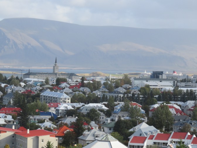
The first permanent settlement in Iceland by Norsemen / Vikings is believed to have been established in Reykjavik by Ingólfur Arnarson around 870 AD as established in the Landnámabók. Steam from hot springs in the region appears to have lead to the name Reykjavik, literally – Smoke Cove or Bay. Temperatures in this cosmopolitan city range from -15°C to +15°C, with a population of 130K and greater Reykjavik having some 230,000 people.
A few facts and figures presented by the guides are: –
- Total population of Iceland as of today is 358,153 (including the 11 babies born yesterday)! 13% are immigrants and of those half are Polish who work in hotels, restaurants and in general the hospitality industry.
- The size of the country is 103 Sq Kilometers or roughly equivalent to England and Wales (without Scotland) or the size of Cuba. There are 3,700 Kilometers of coastline and the ring road around the country is 1,500 Kilometers. It measures 300 miles from East to West and 200 miles from North to South. It is the second largest island in Europe after the UK and lies between 63°N and 66°N Latitude. The reason for the difference in ring road and coastline distances is because of the rugged coastline. The average height is 1,500 feet above sea level with the highest peak being the Vatnajökull Glacier at 7,000 feet and covers some 3,000 Square Miles (8 times the size of Mount Etna in Sicily and is about 1/2 mile thick or more.
- Iceland is a pile of lava pushing up through the Tectonic plate rift pushing the island outward.
- When the Vikings arrived there were many trees but all were cut down for housing and heating. This and the lava fields/ eruptions all lead to Erosion bring a major problem. 50-60 years ago there were virtually no trees. However an extensive tree planting program was instituted as now there are clumps of trees and indeed some are achieving a height of 15-20 feet, but growth is very slow given there is virtually no earth. Today there are 600 varieties of plants and 600 different mosses on the island.
- The Arctic Fox, birds and mink are the only wild animals, with sheep, cows etc being farmed. No reptiles or snakes on Iceland. The mink are there as there was an entrepreneur who started a mink farm to produce coats, some animals escaped and are now a menace. The Arctic Fox can be said was the first animal to live on Iceland.
- In 2010 the Eyjafjallajökull Volcano (E-15 as it was called by the press E +15 letters – unpronounceable) erupted topping European & Transatlantic flights for 6 days and putting Iceland on the map as a tourist destination. Prior to E-15 there were 300K-400K tourist a year which jumped to about 2.5 million a year today. 170 Cruise ships stop in Reykjavik each summer bringing some 250,000 tourists. Thus number increases each year.
- The last major eruption of a volcano took place between August 2014 and February 2015 in the Northern part of the icecap which is uninhabited, so there was no damage or loss of life.
- Currently there 30 active volcanoes of which 4, that due to periodicity, are due to erupt any day now. Katla volcano is under a glacier and may cause even more of a problem that E-15 caused in 2010.
- The country has no military, but does have four coast guard ships (named after Viking Gods) and many volunteer rescue squads in each town to help (mostly tourists) those who are in distress. This was very evident as we walked through lava fields covered in moss that looked solid but upon closer inspection had holes in the ground, meters deep, that one could easily step into and be “swallowed up” by the earth never to be seen again. This is a continuing problem for those that don’t follow the signes, the paths etc that are clearly laid out.
- The center of town street names in Reykjavik are also named after Viking gods.
- An interesting story of a Chinese man who visited Iceland and rented a car. He crashed and totaled it before getting out of the airport. Over the next couple of days he crashed beyond repair two other cars. The rental company would no longer rent him a vehicle for his 2 week stay. It turns out that he had never driven other than 1/2 hour in a simulator and was only granted a license provided he never drive in China. An interesting paradigm!!
- The Church and State are all one and not separated. Thus all church workers are government employees. This leads to a lack of church-going locals and many churches are more museums and concert halls as opposed to houses of worship. Indeed many still denounce the 1000 AD (CE) government proclamation banning the pagan gods and conversion to Christianity. Many locals still associate themselves with these pagan gods. There were 2 bishops, one in the North and one in the South, peacefully co-existing. However there was an issue during the reformation in the 1500’s. In 1543 one bishop was a reformist and the other not, leading to a sort of civil war. The Southern Bishop took the Northern Bishop hostage with his two sons and beheaded them in December 7th 1550. In those days Catholic Priests and bishops were married and had many children. The North wanted revenge and took the Southern Danish Governor with his guards, and hostages and they were placed on a remote island. They were all killed. The Danish king stepped in to stop the revenge killing as it would likely have continued. Today there are 3 Catholic Bishops. One in the North, another in the South and the third in the old Capital which now has a population of 600.
- Iceland is one of the top world countries in Population Longevity, Absence of crime, desirability of living etc.
- The capital City is like any other modern city with wide boulevards, trees. Green plants, shrubs etc. it is only when one goes out of the City & surrounding areas that one realizes the barren lava fields and lunar landscape covering most of the country.
- Most residents live around the coast, the center of the country is mostly lava fields and somewhat inhospitable living. Those who venture there must be self-sufficient, in 4-wheel vehicles and knowledgeable about getting around. Many, who think they are “outdoor experts” venture into the interior or “off the beaten path” never to be seen again.
- Hot Tubs / hot water springs are a general meeting place for locals. It is like the UK has pubs, Iceland has hot springs. After work one goes to your local hot water spot to relax and chat with friends.
- There are about 5 small earthquakes a day which help stop the incidence of more major earthquakes.
- There are 10 airports in Iceland and certainly that is the easiest way of getting from one place to another in the country.
- There are 20,000 students at the University of Iceland in Reykjavik which draw many international students particularly to their Oceanography and Geothermal departments.
- As it used to be that men would go out fishing for the major economic activity of the nation, many not returning, being taken by the sea, much of the household and domestic affairs was left in the hands of women. Indeed the first female democratically elected Head of State was Vigdís Finnbogadóttir in 1980. She was a single mother of one, a teacher and held power for 16 years before returning to being a teacher. The current president is 49 years old, married to a Canadian who has learned and speaks Icelandic well. This is more of a ceremonial role but does have some political power. The major political power lies in the Prime Minister. Currently he is a 42 year old, member of the Left Green Party but to rule has formed a coalition with 2 other parties – The Independence and Progressive parties. The parliament (Al|>ingi – pronounced Althingy) was as formed in 930 AD (CE) about 300 years before the UK. It has 63 MP’s with elections every 4 years. In 2017 the voter turnout was 81.2%. Following the financial crisis of 2008 which hit Iceland hard, the first openly gay Prime Minister was elected – Jóhanna Sigurdardóttir.
- We should recall the famous Summit on nuclear arms reduction between Mikhail Gorbachev and Ronald Regan took place at Hoffi House in Reykjavik, leading to the end of the Cold War.
- In about 2 weeks – towards the end of September 2018, there is to be a Summit of the world’s main powers in Reykjavik to discuss the North Pole, rich in natural products and in view of the melting of the area around the pole, the northern maritime passage above Canada is of strategic importance. This conference will try to lay out boundaries as well as rules and regulations.
- Iceland is one of three nations that still practices whaling. Most countries have stopped the catching of whales, but Iceland resumed this practice in 2006 causing major negative reactions by other states. The majority of whale meat has been sold to Japan, but that nation has started whaling again, thus no longer had a need for Icelandic whale products.
- The first Hydroelectric plant that feeds Reykjavik came on line in 1821 and the first geothermal one to feed the needs of the Capital came on line in 1940.
- The third major industry, after Fishing and Tourism is somewhat surprising. It is the production of Aluminum. There are three very large Aluminum factories in the country for the simple reason that electricity is plentiful and inexpensive. Bauxite is brought from Australia and processed here then shipped around the world. The Alcan – Rio-Tinto factory is vast and near Reykjavik, employing many locals.
- The British had a “friendly” invasion in 1940 mainly to protect against a possible German attack. During this period many roads and other such infrastructure were built. In 1941 the Americans came in and built a large air base, staying until 2006. The US VP Mike Pence was recently here trying to negotiate a re-entry of a US military base as it is now perceived that it was an error to leave particularly given the Northwest passage.
- From 1100 to 1800 AD (CE) Skivery was the Capital of Iceland, before moving it to Reykjavik. The worst years in the country were 1600-1800 under Danish Rule.
Our first tour of the morning – Panoramic Reykjavik (Guide Kolfidan; Driver Thergut, Coach 12) was not a great success as there were many with mobility problems and the guide was average. I must digress to tell the story of Dolly. She boarded the coach, late as always making a grand entrance, complaining that she had to sit in the second seat, right in front of us as there were disabled people in front. Soon after the start of the tour she started nagging the guide about her afternoon tour. The guide was pleasant but was not in a position to answer her questions, however we realized we were on the same tour in the afternoon and thus were going to be subject to her antics again.
As there were so many ‘invalid’ people in this tour, when we reached our first stop – The Valley of the Steam to see the pseudo-craters – just outside Reykjavik, no one was interested in getting off the coach and indeed the hard working guide was getting little response and people were chatting over the explanations, making it rather frustrating.
Our next stop was The Pearl. This is a dome over hot water tanks that store all the hot water for the city. The bore holes let out the very hot water, result of surface water (rain, snow etc) dripping through the lava fields then super-heated by magma under pressure to be liquid at 300°C. When the bore hole relives the pressure build-up and allows the super-heated water to come to the surface it creates instant steam. This is then used to drive the turbines in the Geothermal electric plants and the effluent still at ~80°C is then piped through insulated pipes to the holding area, loosing only some 2°C-3°C. The Pearl stores this hot water and sends it around the city to heat and for hot water in homes, offices, buildings and then piped under the streets to melt the snow and ice. Once used, the now cold water is then allowed to be filtered through the lava fields into in ground thus repeating endlessly the cycle.
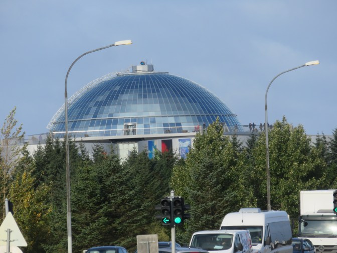
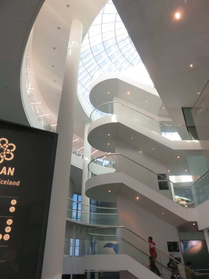
A brief stop here allowed us only to go to the top floor where there is a 360 degree viewing platform to see the city. Very impressive but very cold and windy, so we spent as little time as possible on the circular viewing platform. There is a domestic downtown airport near The Pearl which can be viewed from this platform.
Our next stop was at the very large modern Lutheran Church – Hallgrímskirkja (www.hallgrimskirkja.is) which was designed by Gudjón Samúelsson (of NY’s Brooklyn Bridge Waterfall fame) based on the basalt volcanic columns throughout the nation. The central tower is 73 meters (240 feet) high. It is very austere with one statue of Jesus at the entrance but little other decor. The 15 meter high 5,000 pipe organ is very impressive. In the courtyard outside the church is a statue of Iceland’s greatest explorer – Leifuf Eiríksson who reached America some 300 years before Columbus.


Other buildings were pointed out in the City but, that was basically the tour. Rather disappointing.
We lunched on the ship and were back on the coach for the second tour or the day – “Introduction to Iceland” (Tour 27, Guide Steiner, Driver Rukvilder) which took us to the Viking World Museum, the Mud Pots and Lake.
We drove out of the Capital into the Reykjanes peninsula with it’s moss covered lava fields and several interesting features. The most famous is perhaps the Blue Lagoon, but it is also here that the Reykjavik International Airport stands in Keflavik, site of the old USA Air-force Base until they pulled out in 2006. The US is now wanting to return realizing it was an error to have pulled out.


The first stop after passing the Very large Aluminum Factory was Viking world (www.vikingworld.is) in Njardvík which has a replica of the Íslendingur Viking ship that can be boarded and seen up close. There are very interesting exhibits about the Vikings in the stunning glass building.


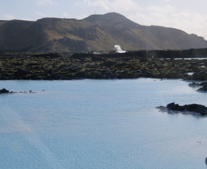
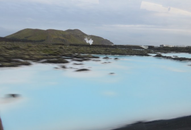
We passed the Blue Lagoon and the Geothermal Electricity generating installation, through the ever changing lava fields, some rocky, some covered with moss while others seemed almost like fields with very low growing vegetation.
Driving through one of the charming fishing villages – Grindavik – we ended up at the “Bubbling Earth” site of Seltun. This was similar to the other boiling earth fields, except that wooden plank walkways avoided the “messy shoe wet dust” syndrome! This is because the sand type materiel in the bubbling fields is very fine and very sticky causing it to cling to your shoes and making it very difficult to get rid of while tracking it all over carpets in the interim.
One could feel the heat of the bubbling earth as we wandered up and down what were like dunes, on the boardwalk. The scene of the surrounding area was a desolate yet beautiful lava and moss landscape with no trees.


The last stop was a spectacular lake with almost bare mountains rising from the deep blue lake (30+ meters in depth).
The scene is ever changing as one goes around each bend, yet each area had a great beauty.


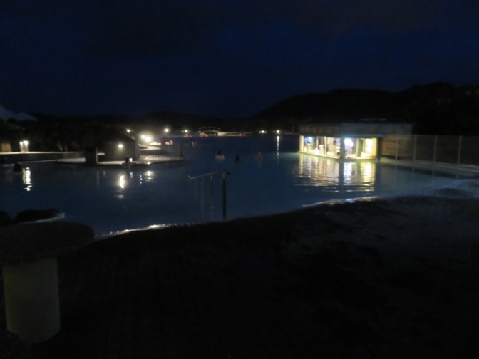
After a quick dinner, we were off again for the evening on a “tour”, as it was really a coach ride to the Blue Lagoon for the evening swim. If you are planning to go by yourselves, you must Pre purchase tickets for the Blue Lagoon (www.bluelagoon.com). You may not just show up and expect to get in. The guide was a total chatterbox making jokes that only she laughed at, so on the return when she announced that she was going to keep quiet, all the coach cheered and clapped. Poor girl, was a bit deflated. However, she did give us some good information about what to expect at the Lagoon. When you arrive and park your vehicle, you can take either the direct walking path along a canyon of piled up lava or the 5-7 minute longer path around the piles of lava along side the river that emanates from the lagoon. We went the direct route and returned the longer route to the coach. As you enter, and pay your entrance fee (about US$120 pp) you are given a wrist band with a chip. This is used for everything. You enter the complex through a turnstile using your wristband chip, headed to the changing room (men and women separate, which we gather is not always the case) and the chip opens and locks your clothing storage locker. After undressing completely it is mandatory to take a shower in a communal shower room and wash thoroughly with soap and water. The locals consider not bathing before entering the thermal lagoon as outright rudeness. After showering and drying off, you put on your dry bathing costume, and head down the stairs to the Blue Lagoon. So called because the color of the water is a milky blue. It is the cooled effluent from the steam that has turned the turbines in the nearby electric plant. You enter the water down a ramp and enjoy the warm water. As one goes further from the sloped entrance it gets deeper and hotter. Crowds were down and we were able to get about easily in the 5 ft deep pool at the deepest. Guards and personnel to aid you were wandering around to help. The first thing we did was to get a rejuvenating white mud and put it over your face and arms. After drying for 10 minutes, you wash it off with the water. Next to the bar that is in the water. You walk up in the water, the bar tenders are dry, and you order your beer or other such drinks paying with a swipe of your wrist band chip.
After you decide to leave the pool (there are various clocks telling the time so if a specific time is set for departure, it is easy to track). You return to the changing rooms. Here some take a shower before getting dressed, while others (we opted for this) decided to keep the minerals on the body overnight and shower in the morning. Again the wrist band chip opened your locker to retrieve the clothes. Prior to using the wristband chip to exit you need to settle your bill. Outside the lagoon, but within the complex there was a food and drink service in the cafeteria as well as a shop offering all the beauty products. We got back to the ship after an hour’s ride (most rested on the way back) after 11 PM.
The following day Saturday September 14, we were up early for the 8 hour tour of the “Golden Circle”. Coach 3, with Sven as Guide, Pal as Driver and Alison from the ship. The guide was very good, gave lots of explanations, but not his or the drivers name until the end.
We drove through Reykjavik with him pointing out various points of interest and told us various stories about Iceland and the area, but the first stop was Öxarárfoss Waterfall in Thingvellir (the “th” is actually the English gloss of the local “|>” line with belly symbol) National Park (www.thingvellir.is). We got off the coach but the rain was coming down, so a toilet break was welcome and then he showed us a relief map of the area. By this point it was pouring rain, so the majority of us decided to get back on the coach. Only 9 passengers in the group opted to do the 1/2 hour walk down the hill, in the rain. The rest of us took the coach and met them at the bottom. It is a UNESCO World Heritage site on account of it’s magnificent natural setting. This was the site of Iceland’s original Althingi (th = |>) or Parliament in 930 AD which laid the groundwork for the culture and regulation of the country. Two weeks each summer the locals went into the valley to socialize and participate in parliamentary proceedings creating the basis of laws and regulations of the country. The last ‘Th’ing (‘th’=|>ing) was held here in 1798 after which the capital was moved to Reykjavík. Not much is left but there is a flagpole which marks the Lögberg or law rock where the leader of the Parliament issued his proclamations. Continuing down the path was the drowning pool (Drekkingarhylur) where adulterous woman would be drowned for their sins. As I mentioned, due to the rain, we missed this.
Our journey continued for some time passing Laugarvatn where there is a cave used to shelter sheep, hot springs for bathing (www.fontana.is), one of which was used by early Christians for baptism (Vigöalaug). We then stopped at “The Golden Waterfall” (Gullfoss). It is a double 32 meter (105 ft) waterfall on the river Hvítá. The upper one is 12 meters and the lower one 30 meters. The gorge is some 2.5 Km in length and 70 meters in depth. The average water flow over the waterfall is 109 cubic meters per second (28,795 Gallons per second), but can reach up to 2,000 cubic meters per second (528,344 gallons per second). We walked along the paths getting amazing views and pictures of the waterfalls. The government wanted to make a hydroelectric plant here given the height and force of the waterfall but a local farmer’s daughter – Sigriöur Tómasdóttir – protested and prevented it from happening thus allowing us to see the raw beauty of nature. As of 1979, it is protected as a National Park managed by the Environment Agency of Iceland. Two theories are exposed as to the origin of the name Gullfoss (gold Waterfall). One is due to the golden evening hue which often colors it’s glacial water. The other is that a local farmer named Gygur who lived in nearby Gygjarhóll had plenty of gold and not wanting anyone else to possess it on his death, he placed the gold in a coffer and threw it into the waterfall. A glacier field was visible in the distance which you could tour with special vehicles (large wide tires that can be deflated from 35 lbs for the road to 12 lbs for the glacier). These can be taken for a drive on the glacier. Time did not permit this, but something for next time!!!


After some time there we went to the nearby Geysers (Geysir) for lunch and time to experience the Geysers and “bubbling” earth fields. The name Geyser used for these natural water spouts comes from this place. The original geyser started in the 13th Century and reached 80 meters (260 ft) has been dormant for a few decades. However, an earthquake in 2000 reactivated it for 2 days. However, there is a smaller one that is still active which we saw. The weather had turned again as we stood in the rain watching for this geyser (Strokkur “The Churn”) to perform about every 10 minutes and reached some 30 meters (100 ft). We stood and watched 3 “performances” trying to capture it on film with moderate success. However, the sight of this bubbling, gurgling earth spitting out a “fountain” of hot water for some 20 seconds each time was awe inspiring and demonstrated the force of nature. As we walked to and from the geyser there were numerous boiling pots of earth with gas and steam escaping. Over one of these “boiling earth pots” someone had placed a small model house so it appeared that the smoke stack was billowing out smoke, actually the gasses from the boiling earth pot. It really is amazing to be so close to such fissures in the earth and see the effects of the heat and molten magma coming so close to the surface.


Geothermal heat just under the surface near these hot spots, creates some unique plant species. Some of these are Blue water speedwell (Veronica anagallis aquatica) green symmetrical leaves and lilac flowers; Small Adder’s tongue Fern (Ophioglossum azoricum) – brilliant 1-3 green leaves with a tongue like appendage at the top of the plant; Inflated Nothcwort (Gymnocolia inflata) brown or yellow moss; Lake Quillworts (Isoetes lacustris) a rare aquatic plant with dark green upright leaves and grows at the bottom of lakes.
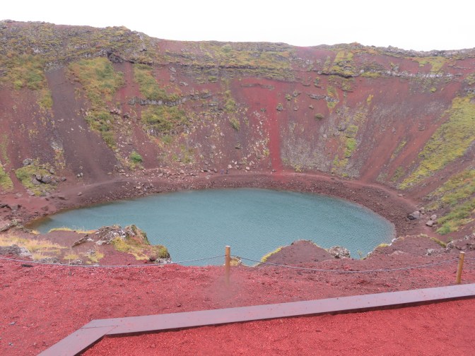
Our next stop was at Keriö explosion crater. It is a very deep (55 meter – 180 ft) blue lake at the bottom of what appears to be a perfectly oval (270 meters long X 170 meters wide) crater created some 6,500 years ago. After further studies and the absence of ash from an explosion, it is now believed to be a large “scoria” crater. Much of the lava in the area came from Keriö. The crater was probably formed by a small magma chamber beneath the crater being emptied towards the end of the eruption resulting in a collapse. Beneath a certain level cavities and fissures in the rock are filled with groundwater, the surface of which is the water table. The water in the Keriö lake does not drain out but rises and falls according to the changes in the water table.
After a brief stop at a lake with steep mountains around the lake, devoid of shrubs, trees or large flora, we stopped at the Hellisheidi Geothermal Power Plant. After a brief welcome from one of the employees we saw a 10 minute video explaining how the Geothermal phenomena is transformed into electricity. In a nutshell, this involves rain / groundwater, over time, draping though the ground until it reached the magma, where it is heated from 300°C to 1000°C, but kept in liquid state under pressure. When a hole is bored into this magma super-heated water reservoir, the pressure is relieved and the resulting steam is used to drive turbines (the ones we saw were yellow and manufactured by Toshiba) creating electricity. The resulting hot condensate of the steam is used to heat homes and roads before returning as groundwater to start the process over again.


Any geothermal regions of the earth (where tectonic plates meet) can develop this type of electrical energy.
We made our way back to the ship and soon were on our way. A fascinating time visiting this amazing country. We are determined to return to visit a lot more of the island.