Tuesday, February 18, 2020 – Puerto Madryn, Patagonia, Argentina
Puerto Madryn is in the Golfo Nuevo in the northern region of Patagonia known as Chubut. The area was first populated by Tehuelche natives until Welsh settlers arrived on the Mimosa on July 27, 1865 after a 3 month voyage from Liverpool. It was named after Baron Madryn of Wales. In 1886 there was a railway line opened to Trelew and closed in 1961. The town was going downhill fast until the construction of the deep water pier and opening of the huge Aluminum factory with hydroelectric and now wind farms providing the required energy. The 1889 railway station was re-purposed into s bus terminal and new fish processing plants were built in the 1980’s expanding the fishing industry. It is the gateway to various nature reserves resulting in the influx of eco-tourism. It is situated nearly midway between Buenos Aires (865 miles North) snd Ushuaia (1,120 miles South) and is at the same latitude as Hobart in Australia.
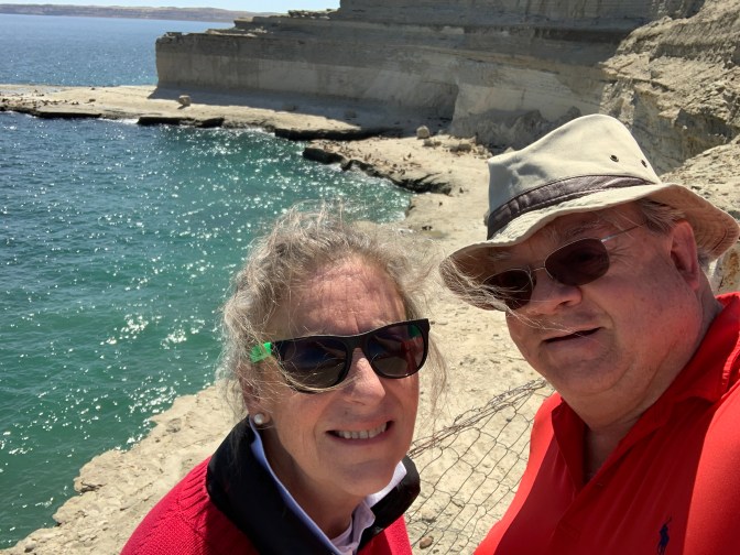
We met our driver / Guide Leandro as we got off the ship (starboard to long pier) who was excellent. Puerto Madryn (stress on “a” not the semi-vowel “y” as would be expected as stress is usually on the ultimate vowel if word ends in “n” or “s”) is a good sized town of 125,000 people. Leandro (leandrocalo@gmail.com) is a freelance driver guide for Argentina Vision Tourist Services – At. Julio A. Rica; Puerto Madryn – Chubut; Y9120AIS Patagonia, Argentina +54-280-44-55-888 or +54-280-44-56-888; info@argetinavision.com; http://www.argentinavision.com.
We quickly made plans to do the 400 kilometer route North-East to the Valdez Peninsula Nature Reserve (1,400 Square Miles in Area) which is actually privately owned by some 50 families who agreed to abide, in perpetuity, to certain eco-friendly arrangements as opposed to it being expropriated by the government. Other options for our day, would have been to go South to Trelew, Gaiman (a Welsh village and Tea house), Rawson and evening further South to Punta Tombo nature reserve.
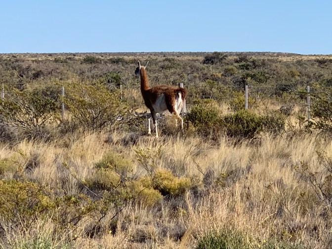
We headed down the long pier with nice beaches to the left and green algae filled braces to the right (between the Cruise port and the commercial pier / port) along the coast road (Av Guillermo Rawson) to Av. Kenneth Woodly / Route 1 to Route 2 past the Isthmus Aneghino to the only town on the peninsula – Puerto Pirámide. Just before getting to the Isthmus, we passed through a toll booth, paying the US$30 for a couple. At this point, the paved road became gravel and remained such all the way around until we got back to this point. In the area before and particularly in the isthmus (between the San Jose Gulf and the New Gulf – Where the ship docked) We were fortunate that we stared seeing the local wildlife. The first one was the Guanaco which is like a small humpless Camel / llama. It has no natural predators so the population is ever increasing and now numbers some 15,000 on the peninsula often referred to as the Island of Valdez, but is connected to the mainland.
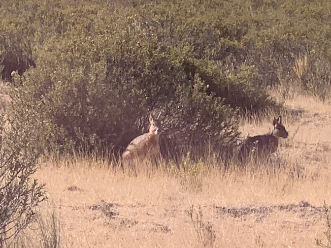
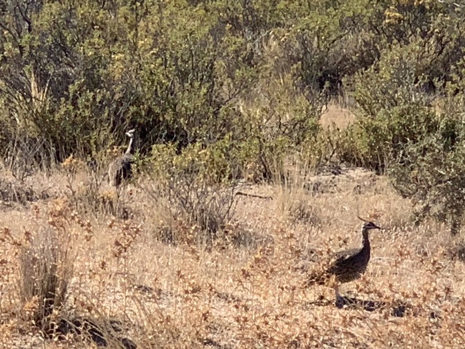
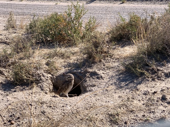
Leandro was amazing as he found a series of animals that to us blend into the semi-desert surroundings. Rainfall is about 10 centimeters (4 inches) of rain a year! Other land based animals we saw were Mara – a large rabbit like animal that is very rarely seen; Choique Miañu Patagonico / Abestruz / Darwin’s Rea, an ostrich like bird and Piche (Hairy Armadillo) and even an owl about 1.5 ft high that makes it’s nest in holes in the ground. The one we saw (at 10AM) was standing outside his home looking around to see what was going on. Amazing as they are usually nocturnal.
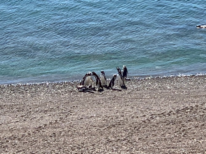
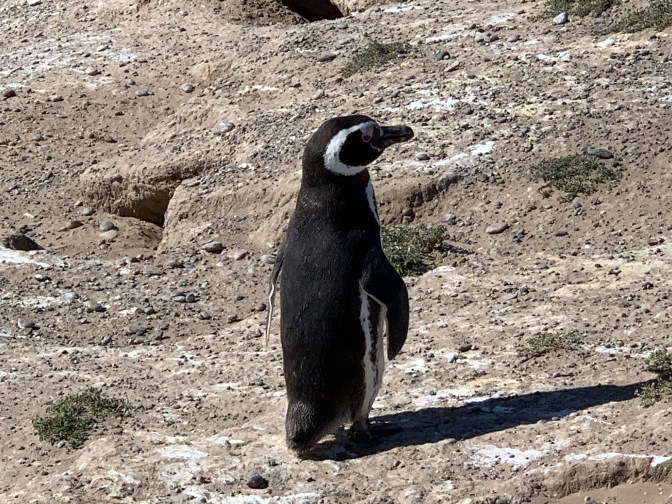
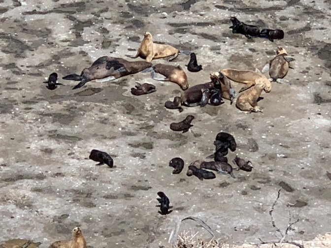
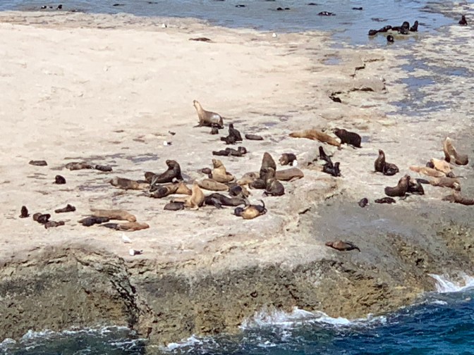
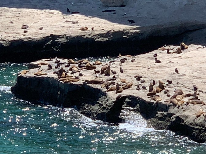
The area is noted for it’s whale watching and indeed the symbol of the town is the tail of a whale. They come to the area from September to December each year, so we were not able to see any whales, but we were able to see a lot of aquatic life in terms of the Magellan Penguins, Southern Elephant Seal and Southern Sea Lions.
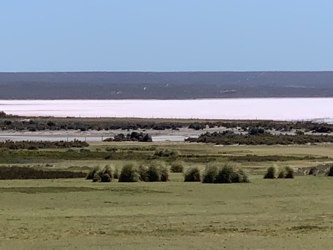
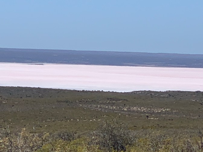
We went straight Past Punta Piámides (we saw several tour coaches there so wanted to get ahead of the crowds and see the places without a lot of people, which was perfect) then turned North (left) onto Route 3 towards Punta Norte but turned about half way there into Route 52 to Caleta Valdes bear the “El Salitre” Salt flat (6 meters / 20 feet below sea level). There are 3 salt flats indicating that the area at some point was under water. The sea water evaporated thus leaving the salt. Of the three salt beds, one is not usable as it contains a lot of nitrogenous minerals that are poisonous, but the others are pure salt (sodium chloride). At one point in history, this was the main industry as it was the only way of preserving food by immersing it in salt.
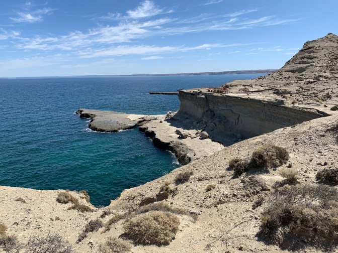
Caleta Valdes is a very intriguing bay as it has various island type protrusions that have occurred over the years due to the shifting sands of the ocean. We stopped at 2 points on the Caleta Valdes bay. The first one “Parador La Elvira” in where we were able to see, up close and personal, the Magellan penguins and see lions just strolling along the beach and resting with many other seabirds like oystercatchers, cormorants and gulls. It was spectacular scenery and so great to see the animals in their natural habitat. We were fortunate not to come across the Yarara Ñata snake (Patagonian lance head / Bothrops ammodytoides whose venom is toxic to humans causing death!!!
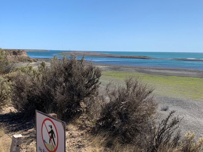
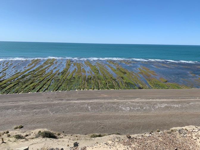
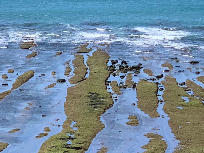
The second stop Punto Cantor on a promontory was one of the most spectacular natural views anywhere. Al low tide, we saw these finger like ripples of algae interspersed with water, rocks and sea lions. The ripple sand / substrata causes high and low long fingers at right angles to the beach, where the raised sections are full of green filamentous algae while the depressions still have water. It almost is like a river delta with the river (of algae) dividing into various rivulets As it reaches the ocean.


From there we went South along the coastal road to Punta Delgado. Many sheep were about and lamb is more common to eat than beef in this area.
Back in Route 2 past Salina Chica (16 meters / 53 Feet below sea level) Salina Grande (40 meters / 131 feet below sea level and 36 hectares in size / 88 Acres) to Punta Pirámide. The Salinas or salt flats are now almost not mined at all, but during the rainy season, small pink crustaceans get into the water and as the water evaporates the salt fields develop a pink hue.
The pyramid point has a spectacular 270 degree view over the bay. Below the viewpoints are beaches which at low tide covered with seals, sea lions and sea birds. Large expanses of land are exposed and make a great gathering place for sea lion families. We saw various groups with their young.
Our final stop was at Puerto Pirámide town for lunch at The Parasise restaurant & Hotel (www.hosteriatheparadise.com.ar). The langoustines in garlic were delicious and served over large potato crisps, followed by Lamb schnitzel with cheese washed down by a local “Guanaco” wheat beer.
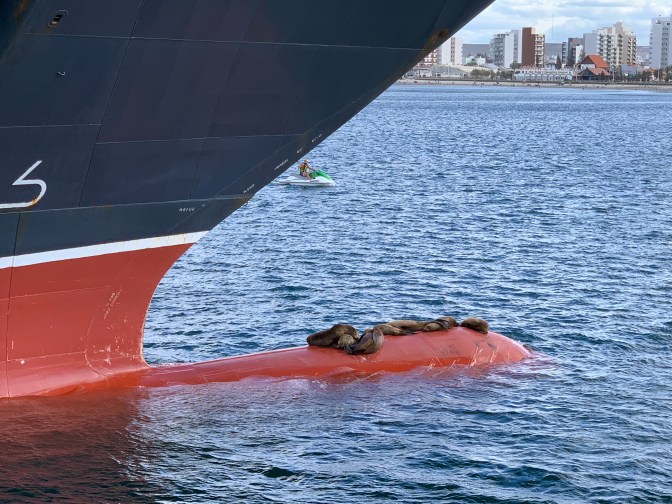
As we returned to the ship we found seals resting on the bulbous structure protruding from the ship’s bow that breaks the water.

At night the show included David Meyer playing the Xylophone-Synthesizer and laser beam synthesizer (green laser beams were focused upward and when the beam was broken by his hand, it evoked a noise through a synthesizer and by interrupting different beams for different lengths of time, music was created).
