Wednesday, February 19, 2020 – At sea en route to the Beagle channel and Ushuaia.
The first rough day at sea with a severe storm force 10 on Beaufort scale over 56 knots / 65 mph / 103 kph winds and 12 foot sea that was coming up to our cabin on 6th floor. This area is often rough as it has the colliding currents (the cold Falkland Current) coming around Cape Horn where the Atlantic and Pacific Oceans meet.
A port lecture by Ruth on Puerto Montt was followed by Lord King of Lothbury – Governor of the Bank of England from 2003 to 2013. A very interesting talk on the economic crisis of the 1930’s, the 2008 and the prospects for the future.
Richard Crowley spoke on the origins of the Tango. It was born of African, Cuban and poor River Plate people, getting it’s start in bordellos. Thus it’s sexy somewhat violent theme. As it became more popular, due to a lack of women the men danced with themselves practicing as only the best dancers were able to have a woman to dance with. It was eventually expanded and became popular in Europe and gained popularity in the Argentina / Uruguay region. In the last couple of decades it has been replaced amongst the young with international music and today is more for shows, but seeing a small comeback.
Dr. Robert Wilder spoke on future sea levels and made a good case for CO2 levels, rise in water levels around the world and the future of the climate both if no change is made to our current way of operating as well as what recovery could be made if total stop of fossil fuels were made. Effects made today may not be seen until years from now.
Due to the heavy seas we skipped the formal dinner, but were glad to see the very amusing and energetic Mike Doyle who we had seen seen late last year on Queen Mary II.
Thursday February 20, 2020 – At sea rounding Cape Horn (Cabo Horno) and back up to the Beagle Channel towards Ushuaia.
We travelled down the coast of Argentina, passing the Falkland Islands after a very choppy night during which we had force 11 (out of 12) winds on the Beaufort scale and wave height reaching to 14 feet. Our cabin on Floor 6 was being splashed by the waves and the ship was really “Rocking and rolling”. The Captain even asked that we secure any valuables on tables as they could be dislodged.
Nevertheless, Today Feb 20, the Captain, based on the weather forecast decided that it would be best to go around Cape Horn today as opposed to the scheduled day after tomorrow. On that day, force 11 to 12 winds were expected.
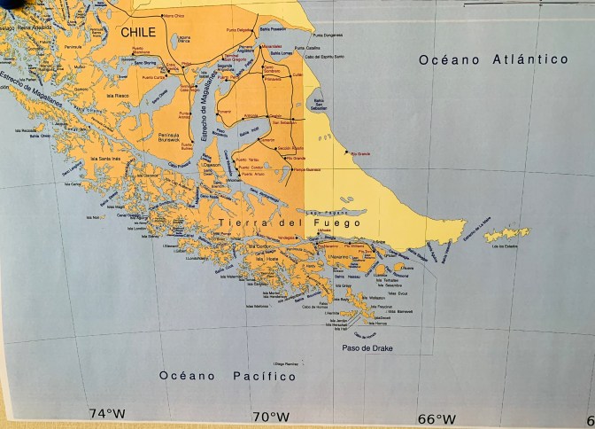
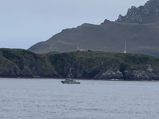
The plan is to travel South past the Magellan straights, past the Beagle channel around Cabo San Diego in Tierra del Fuego, Argentina then through the La Maire Straights between the Island of the States and the large Tierra del Fuego Island, to the southern-most island “Cape Horn” (Cabo Horno as it is called by Chile) in the Drake Passage. We arrived at 6:30pm and as the winds were West to East, we circumvented (went all the way around) Cape Horn with the Port side towards the Island. It took until 8:30 pm at which time we headed back up North to the Beagle Channel navigating overnight between Navarino island to the South past Pictor and New Islands and The Large Tierra del Fuego Island to the North getting to Ushuaia, Argentina by morning.

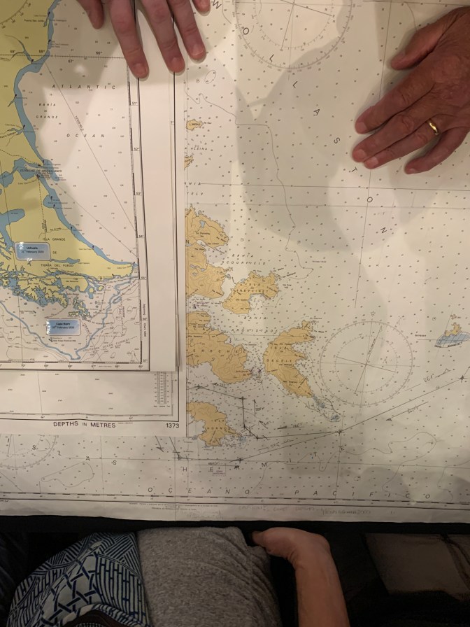
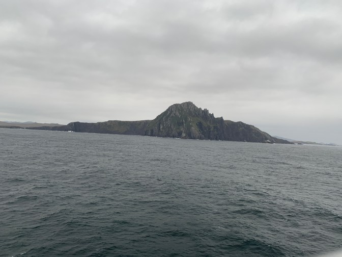
Cape Horn is located between the Atlantic and Pacific Oceans at 55•59’ South Latitude and 67•19’ West Longitude. It is known for its turbulent currents and strong winds all of which can change at any minute. The first time Europeans saw the Island of Cape Horn was in the early 1600’s.
In the small port of Höon, the French merchant ship Isaac Le Marie with the sailors Guillermo Cornelia and Juan Schouten signed the Constitution of the Southern Company snd fitted out two ships – The 360 Ton Endracht (unity) and the 110 Ton Höon which sailed from Texas in the Netherlands on June 14, 1615. On January 24, 1616 they crossed the straits which they called Le Marie and gave the name Statenlant (Land of the States) to the land they sighted to the East. They called it ‘Land’ as they thought it was a peninsula of Terre Australis Incognita, and of the ‘States’ in honor of the provinces in the Netherlands that were fighting for their independence which were – Holland, Zeeland, Friesland, Utrecht, Drenthe, Gelderland and Groningen.
On January 29, 1616 they rounded the cape which they called Höon, opening up the route from the Atlantic to the Pacific. It is said that no sailor will kill an Albatross as these birds are supposed to carry the souls of sailors who have lost their lives at sea.
There is a monument on Cape Horn which was inaugurated on December 5th 1992 by the Chilean Association of Cape Homers in memory of the many seamen from all nations that have perished in the battle of inclement weather. It is 7 meters (22 feet) high and will stand up to winds of 100 knots (115 MPH). On the path up to the monument are two structures that support marble slabs. The monument dedication information is on one of these and on the other is a poem by the Valparaiso poet Sara Vial staying:- “I am the albatross that awaits you at the end of the earth. I am the forgotten soul of the dead sailors who sailed all around Cape Horn from all the seas of the world. But they did not die in the furious waves, today they fly on my wings towards eternity, in the last crevice of the Antarctic winds”. It is estimated that between the 16th and 20th centuries more than 800 ships have sunk and 10,000 people (mostly men) drowned in these waters from all around the world.
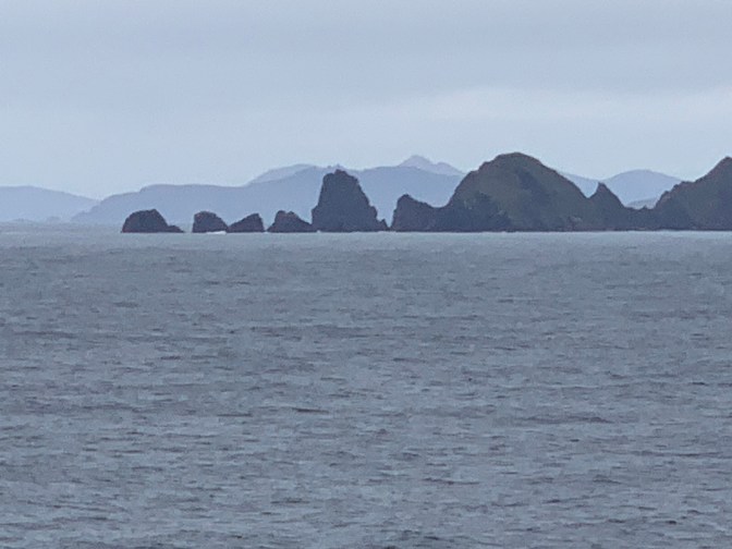
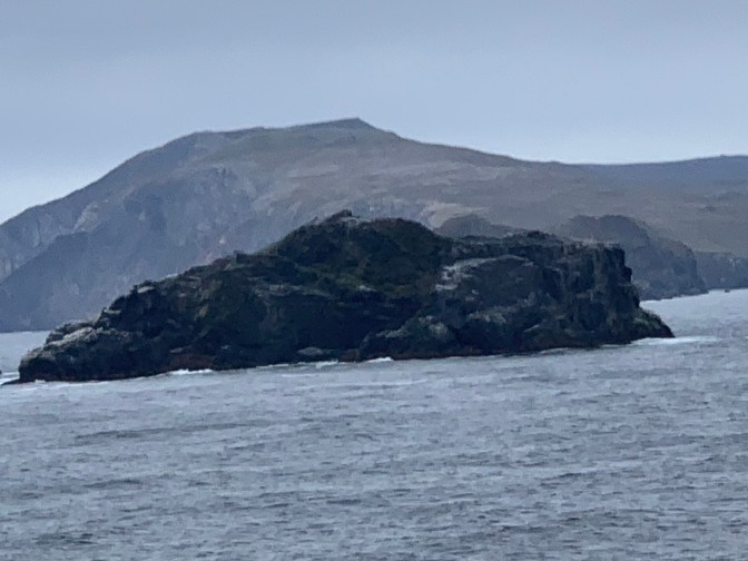
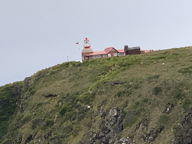
When we got there The weather was overcast light rain and bumpy. However, when we got closer to Cape Horn, the weather lifted the seas became like glass and we had great visibility. The captain stationed the ship in front of the lighthouse, lighthouse keepers house and Cape Horn monument and did a full 360° pirouette so that everybody on the ship could get a good view of the “Bottom of the World”. It was truly spectacular and we were able to get many pictures of this barren rock at the very bottom of South America, which led many sailing ships to their watery Graves! We were even able to see and wave at the lighthouse keeper his wife and three children, the last of which was born two months ago on the island. The Chilean Navy have the lighthouse keepers spend one year at the station before they are replaced. A truly inhospitable place. We then travelled slowly all the way around Cape Horn returning the way we had entered the area towards our next port.

We will spend Tomorrow in Ushuaia and then the following day, head back out East-South-East along the Beagle Channel getting back to the Atlantic Ocean before heading North, with the Argentine Coast to our Port side until we reach the Magellan straights. We then travel West along the Magellan straights at the top of the Large Island of Tierra Del Fuego, stopping in Punta Arenas, Chile. At which point we head South-West through the Magellan Straights, rounding Peninsula Brunswick then North West between Santa Inéz and Riesco Islands into the Pacific, then North through the Chilean fjords to the glaciers.
On our way to Cape Horn the local Archaeological expert – Marisol Vereda talking about the “Aónikenk” and the first contact with Europeans. It is said that Patagonia (Pata Goina [Grande] = Large Foot) got it’s name from the “giants” with large feet that lived there (Average height 6-7 feet Vs Europeans at 5 feet high).
Ruth Clamp spoke on San Antonio, Chile – The port for Santiago, Valparaiso snd Viña Del Mar Chile.
Michael Halvarson from Cirque du Soleil and Broadway’s “The Illusionists” performed magic on the evening stage to average reviews.
